Contents area
Current natural hazards situation in Switzerland


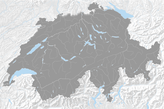
Complex visual representation of the current natural hazards situation in Switzerland. The identical information is available in text form below.
-
Forest fire: Considerable danger, level 3
Effective from: 14.11.2025More information on measures in force in the cantons to be found on the FOEN Website.0:Forestfire:3:ForestFire:328,344,305,1804,306,307,335,1802,303,304,301,345,324,312,333,316,317,346,302,315,1803,308,310,334,319,309,336,318,331: -
Forest fire: Moderate danger, level 2
Effective from: 14.11.2025More information on measures in force in the cantons to be found on the FOEN Website.1:Forestfire:2:ForestFire:1014,342,338,311,1013,1009,339,600,1010,1018,1805,1800,341,327,326,313,340,320,323,332,322,321,329,325,337,330,314,1801,350,343,347: -
Wind: Moderate danger, level 2
Validity: 14.11.2025, 09:00 - 15.11.2025, 06:00- Possible impacts: Breaking of smaller branches.
- Recommendations for action: Secure any freestanding objects outdoors or move them to a sheltered spot (e.g. plant pots, garden furniture, bicycles) before the wind event begins.
- Highest wind gusts in exposed locations: 70 - 95 km/h
- Main wind direction south2:Wind:2:MCH:147,163,155,179,148,168,167,138,178,164,156,171,145,154,176,177,128,170,175,137: -
Earthquakes: No or minor danger, level 1
14.11.2025, 20:39 Magnitude 2.6 earthquake at Aiguille de Leschaux I. Potentially felt in this warning area. No damage likely.3:Earthquake:1:MCH:232,233,234,235,236,237,238,240,241:178,443 -
Earthquakes: No or minor danger, level 1
13.11.2025, 13:39 Magnitude 2.8 earthquake at Quart I. Potentially felt in this warning area. No damage likely.4:Earthquake:1:MCH:233,234,237,238,240,241,243,245,248:246,467 -
Drought: No or minor danger, level 1
Effective from: 13.11.2025- Impact: No (significant) impact.
- Recommended action: No recommendation for action.5:Drought:1:HydroRegion:37,46,32,33,65,34,35,36,59,60,61,62,38,40,41,42,39,43,45,47,48,49,50,51,52,53,54,55,56,57,58,63,64,66,67,31,44,68: -
Flood: No danger level
Validity: 14.11.2025, 11:00 - 16.11.2025, 11:00A flood danger assessment for small and medium-sized waterbodies cannot be made for this area. There are no danger levels.6:Flood:0:HydroRegion:53: -
Earthquakes: No danger level
13.11.2025, 22:03 Magnitude 3.0 earthquake at Lillaz I. Probably not felt in this warning area.7:Earthquake:0:241,585 -
Avalanches
In the summer and autumn, avalanche bulletins are published only in the event of heavy snowfall. Even if the SLF does not publish an avalanche bulletin, due consideration is to be given to the avalanche situation especially if snow has fallen recently.
Keep informed about the publication of unannounced Avalanche Bulletins. Activate in the App WhiteRisk the "Push Summer Bulletin".
The regular publication of avalanche bulletin recommences in November/December.8:Avalanches:-1:SLF:1111,1112,1113,1114,1121,1122,1211,1212,1213,1221,1222,1223,1224,1225,1226,1227,1228,1231,1232,1233,1234,1241,1242,1243,1244,1245,1246,1247,1311,1312,2111,2112,2121,2122,2123,2124,2131,2132,2133,2134,2211,2212,2221,2222,2223,2224,3111,3112,3113,3114,3211,3221,3222,3223,3224,3311,4111,4112,4113,4114,4115,4116,4121,4122,4123,4124,4125,4211,4212,4213,4214,4215,4221,4222,4223,4224,4225,4231,4232,4241,4242,4243,4244,5111,5112,5113,5121,5122,5123,5124,5211,5212,5214,5215,5216,5221,5222,5223,5231,5232,5233,5234,6111,6112,6113,6114,6115,6121,6122,6131,6132,6211,6212,7111,7112,7113,7114,7115,7121,7122,7123,7124,7125,7126,7211,7221,7222,7231,8111,8112,8113,8114,8211,8212,8213,8214,8215,8216,8221,8222,8223,8224,8225,8226,8227,8228,9111,9211,9311: